Yap Geography & Climate
Location & Size
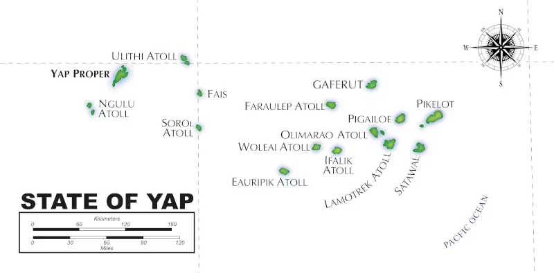
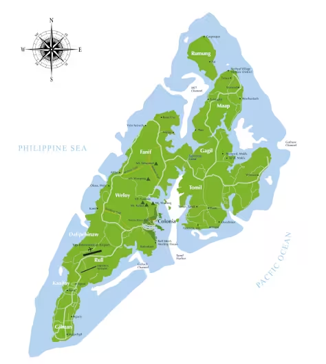
Yap is a cluster of islands located just nine degrees north of the Equator and stretching for 600 miles (965 kms) across the vast Pacific Ocean. It is one of the four states of the Federated States of Micronesia (FSM) with the others being Kosrae State, Pohnpei, and Chuuk. Yap proper, is a group of four main islands that are volcanic in origin: Rumung, Maap, Gagil-Tomil and Yap.
They are all located within a barrier reef, and approximately 500 miles southwest of Guam, 300 miles northeast of Palau, and 950 miles due east of Cebu, Philippines. In terms of territory Yap State covers over 100,000 square miles, but the total land mass portion of that is quite small - only 45.9 square miles, 38.7 of which makes up Yap Proper.
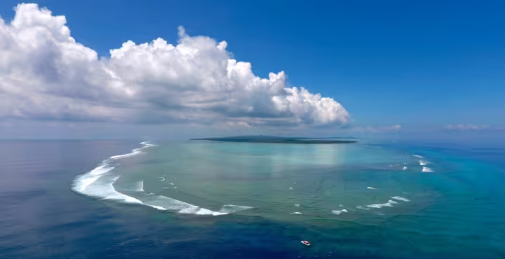 In total there are approximately 149 distinct land masses, of which around 22 are currently populated. The Outer Islands of Yap are mostly atolls - wisps and curls of coral and sand, rising just enough above the Pacific’s waters to support the tiny strand of green jungle and coconut trees that sustain the atolls’ inhabitants. Despite the tiny land masses, the atolls often have huge lagoons. In fact, Ulithi’s lagoon is the fourth largest in the entire world and harboured as many as a thousand ships at one time during World War II.
Topography
The main islands that comprise Yap proper are only about 16 miles long and 8 miles wide and boasts a large number of cross island waterways, inlets and channels, and an extensive shoreline that creates and illusion of greater size. The entire islands are surrounded by a fringing reef which ranges from one-half to two miles long and encloses ten square miles of lagoon. There are several natural breaks in the reef. The largest break is the narrow entrance to Tomil Harbor about two miles north-northwest of Colonia. Many of the villages in Yap are located near the shoreline and arable land. Each village has its own distinctive character, but generally speaking, houses are located just off the well-kept, hedge-lined main thoroughfares and stone paths — far enough away from the shore to avoid flooding in the event of a typhoon, but close enough to feel the gentle breeze which blows through the islands most of the year.
 The highest point in Yap Proper is is Wacheq Mountain in Weloy Municipality, which rises almost six hundred feet above sea level, offering spectacular views of Yap’s ten municipalities. Much of the land is rugged and hilly, especially the northern area of Maap, but lush pockets of vegetation are visible in every direction. Gagil and Tomil stand out because of their distinctive red clay valleys and ridges. Fanif and Weloy are notable for their thick jungles and the many coves, islets and small islands which dot the shorelines. Further south are Rull and Colonia - Yap’s version of the big city, which, with its one main intersection is still very much like a small frontier town. Past the airport lies Nimgil — a regional name encompassing the southern end of Dalipebinaw, Kanifay, and Gilman municipalities - notable because of its proximity to the reef and rich mangrove forests.
The soil in Yap is generally quite poor and significant portions of the island are considered badlands or are covered only by savannah grass and curious looking clusters of pandanus trees. Much of the arable land on Yap Proper is found near the coastline or in the valleys between Yap’s hilltops. Much of the shore area is covered with mangroves or rocks, but the islands of Yap Proper boast twenty beautiful sandy coconut tree-lined beaches. Maap, Fanif and parts of Gagil offer the best combination of beaches and beautiful reefs.
Climate
Temperatures in Yap are moderate and fairly constant. Average temperature during the Spring and Summer months is 82 Fahrenheit and 80 Fahrenheit during the Fall and Winter. Relative humidity ranges from 65 to 100 percent. Rainfall averages 120 inches (3,048 mm) a year but is seasonal. The heaviest rains tend to occur in the summer months while the winter and spring trade-wind season (marked by strong east to northeast winds) is relatively dry and often marked by drought. The transitional months of May, June and November are considered peak typhoon season.

